Mexican Rancho Period (1831-1847)
After Mexican Independence from Spain (1821), the Rancho Rosa de Castilla (Rose of Castile Ranch) was granted in 1831 to Juan Ballesteros as depicted in Figure 6. He was the Regidor of the Pueblo of Los Angeles from 1823 - 1824. The Rancho was named after the stream running through the area. [The stream is the same one mentioned earlier that runs east of present-day Guardia and Farnsworth Avenues. The stream continues to run up to the present day, a small portion of it can be seen adjacent to Cal State LA and the 710 freeway. You can see the arroyo as you enter the 710 S on Valley Blvd. See LA Times article dated March 8, 1992, located below, in the American Ranch Period (1848-1901) for more info about the stream] This stream was called the Arroyo Rosa de Castilla because of the roses growing on its banks. It includes what is now Lincoln Heights, El Sereno, City Terrace, and parts of South Pasadena, Alhambra, and Monterey Park. After the secularization of the missions in 1833, the ranch passed to Francisco (Chico) Lopez. He had a home in Paredon Blanco (now Boyle Heights), but kept his cattle here. In 1840 he expanded the adobe on the ranch which had been built by workers from the Mission in 1776. This adobe was located in what is now the City of Alhambra near Westmont Drive and Jurich Place as depicted in Figure 7. [The adobe was destroyed in a fire in 1908 during the making of an early silent movie, see Wiki & Mr. R. Lerner document.] In the later 1840s he obtained title to a ranch near Lake Elizabeth in northern Los Angeles County and moved his cattle from Rancho Rosa de Castilla to this ranch.
This map shows the historical areas and boundaries of the City of Los Angeles, Rancho San Rafael, San Gabriel Mission (which includes El Sereno), and the various other historic Ranchos formed during the Spanish and Mexican Rancho periods. El Sereno was part of the San Gabriel Mission until the El Sereno area was passed onto Juan Ballesteros in 1831, under the name of Rancho Rosa de Castilla. El Sereno's area continued intact, passing over into the Batz's Family Rancho Rosa de Castilla in 1852. El Sereno has maintained it's land and community unity up to the present time, with only some parts being absorbed into the cities of Alhambra and Pasadena/South Pasadena (See Figure 11). Some of these areas would be added back to El Sereno in 1915, when the El Sereno area was finally annexed into the City of Los Angeles (See Los Angeles Annexation and Community Establishment Period {1912-1929}). Figure 6 is also useful as evidence of El Sereno's historic ties to the area. Click on map below to enlarge and see further details of El Sereno's connection to the area.
El Sereno has almost the same historical boundaries with Los Angeles today as it did when the City of Los Angeles and Rancho San Rafael were created (1781 and 1784respectively). El Sereno sits between the Camino Real to it's South, Rancho San Rafael to the North, and the City of Los Angeles/Lincoln Heights to the West (the community Lincoln Heights has always been in and part of Los Angeles. Lincoln Heights falls within the original 36 square miles that were part of Los Angeles foundation in 1781).
Rancho Rosa de Castilla and Los Angeles
Another great map showing the boundaries of Rancho Rosa de Castilla and Los Angeles. From the map we can see that Rancho Rosa de Castilla extended up to the boundaries of L.A. and Rancho San Rafael, although at the time the map was made, the area was known as Rancho Verdugo. The original and huge Rancho San Rafael had already been divided.
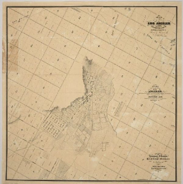
Caption: Map of the city of Los Angeles showing the confirmed limits surveyed in August 1857 by Henry Hancock Shows drainage, block and lot numbers, land ownership, buildings, fields, etc All street names are in both English and Spanish.
Map of Los Angeles city lands in September 1, 1858, [s.d.]
Map of Los Angeles city lands in September 1858, [s.d.]. At center an almost-square boundary is visible with "Los Angeles" written inside of it. Above the boundary, Rancho Los Feliz, Rancho Canada, and Rancho San Rafael are indicated. To the right of the boundary, Rancho Rosa Castillo and Public Land are indicated. Public Land is also depicted at left and bottom, and Rancho San Antonio is depicted at bottom right. Photoprint reads: "Plat of the City Lands of Los Angeles finally confirmed to the Mayor and Common Council of the City of Los Angeles. Surveyed under instructions from the U.S. Surveyor General by Henry Hancock Dep. Sur September 1858 Containing 17.172 37/100 Acres".]
Click on map for link
Official Map of El Sereno
Current and Official Map of our El Sereno community. We can also see the boundaries between the communities El Sereno/Lincoln Heights. There has been very little change between the boundaries when compared to maps dating to the 1850s.
Figure 11
El Sereno has maintained it's land and community unity up to the present time, with only some parts being absorbed into the cities of Alhambra and Pasadena/South Pasadena.
This website uses cookies.
We use cookies to analyze website traffic and optimize your website experience. By accepting our use of cookies, your data will be aggregated with all other user data.

